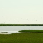
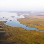
Slano Kopovo lake basin is the deepest part of palaeomeander in Banat and it’s one of the few salty aquatic preserved in the area of floodplain soil of the lowest part in Pannonian basin called Potisje. In the past, the river Tisa used to change its course frequently, flooding the nearby plains. Since larger rivers from the Carpathians did the same, it created ponds in the numerous relief depressions so marshes were prevalent in Banat. After the marshes were drained in the 17th and 18th century, dams were built and channels were dug, and many ponds were dried out. One of few ponds that avoided this was Slano Kopovo.
 Slano Kopovo is one of the river Tisa ancient meanders, i.e. geomorphological form that river water created. That means it belongs to a group of river or fluvial lakes. It’s in the shape of horseshoe whose prongs are facing the south. Parallel to Slano Kopovo, on its eastern side, is Small (Poštaš) Kopovo -narrower depression. It is surrounded by marsh vegetation and belongs to freshwater type of marshes that don’t have permanent water, unlike Slano Kopovo. Slano and Small Kopovo are divided by slightly higher land – the distance between them is 350-900m.
The eastern side of Slano Kopovo basin has glacis. Above the west side is the steep section of wood terrace of Banat, approximately 6m high. The highest point is on the Maslar hillock which is 86,6ma. In the north and the south of the lake’s basin, there is dry or occasionally flooded bottom of the ancient meanders. The research showed that the bottom is covered with clay and it has glacis.
 The water of Slano Kopovo spreads towards south-east, north-west. It’s in the shape of ellipse. During the average water level, by along the axis, it’s 3m long. It’s the widest in its north-west part – 625m. The south-east part of Slano Kopovo ends with a constriction, where it’s only 50m wide. The area of Slano Kopovo depression is 1,45 km2.
The lake fills itself with rainwater, surface water in draft and with subterranean waters. Since the lake hasn’t got flaw away, the water evaporates which is especially visible today.
 The ground of the lake is very salty – солончак, Russian and Tatar word for “much salt“. The concentration of salt, chloride and sulfate, in this area is more than double from typical salt marshes in Vojvodina. The chemistry and the saltiness of water depend on the geological substrate. Slano Kopovo water is extremely base reaction (pH 9,0 – 9,4). The average water depth is about 70cm, but it isn’t constant and depends on a water balance. In the most part of the lake, the depth is about 20cm.
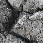
The salt and the water are the basic ecological factors which dictate the living conditions. They influence, immediately and indirectly, all ecological factors of the area. The origin of salt is explained with the Pannonian Plain characteristics. It is surrounded with the Carpathians that have igneous rocks and crystalline schist in their rocks. These free elements were carried on in the rivers from the Carpathians into the Banat Plains. Being dissolving salt, they salted the ground. In the climatic conditions of drought and semi-drought Vojvodina, where evaporation exceeds rainfall, the level of salt is increasing, especially in summer months. Because of that, the water retreats very often from Slano Kopovo which leads to the accumulation of a salt layer sometimes several centimeters thick. This layer of salt gives the area the look of a desert.


 Follow